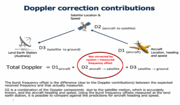
 The Inmarsat is the leading organization on satellite monitoring which was established in 1979 by the International Maritime Organization (IMO). Its main focus is to enable ships to stay in constant touch with any available ports and shores in order for them to get help if anything would happen to the vessel. The Inmarsat will connect ships and vessels no matter how far it went out to sea.
The Inmarsat has more than 60 location world-wide and provide around the clock support facilities for their patrons. Although it is a commercial based system, the Inmarsat are also involved in many search & rescue operations. They will provide and analyse data to be given to relevant authorities in such operation. After 35 years Inmarsat has emerged as the leading provider of Aerospace and Maritime information.
After 9th of March 2014, Inmarsat has been a household name in Malaysia. Before this, Inmarsat is known only to those who are involved in the maritime business, but now from the hawker stalls in Jakarta to the Malaysian Parliament in Kuala Lumpur, everyone are talking about Inmarsat and their contribution towards the search & rescue mission of flight MH370.
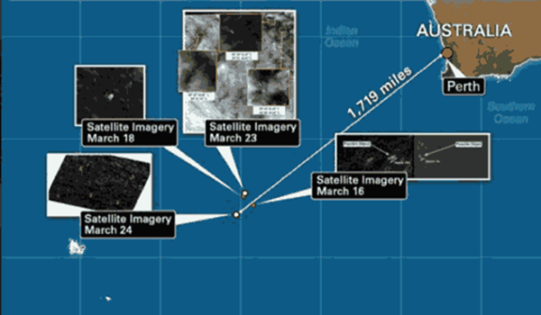
Some might think that satellite imagery that Inmarsat and militaries from the 26 nation is easily interpreted. This is the result of watching too much Hollywood movies. The raw data from satellites does not come with a clear full coloured image. Raw data are represented by a plotted image that must be processed by using complicated coding. Satellite imagery is not like when you take picture with your digital camera. It is more complicated than that.
A lot of criticism had come from the foreign and local media saying that the Malaysian government has not released the full information on the data collected by the search and rescue operators. Some has even criticized the blurry image of the satellite image saying that the government intentionally distorted the image so that the public cannot see the real condition on what is happening in the Indian oceans. Well, the truth is, this is the best that we can get out of the satellite photos. The Malaysian government has even released raw data to ensure that the public is up to date with the current scenario.
Malaysia has done its best to provide the facilities that is needed to find out what had happened to flight MH370. However, there are parties who think that that the government doesn’t doing enough just because they don’t understand the concept and method used by the search and rescue operator. On a lighter note, Malaysia was praised by all of the commanding officers of the 26 nations that were directly involved with the search operation. US Navy Commander William Marks stated that the Malaysian government has done an exceptional job in coordinating the water-space and airspace management in finding the plane.
Even though criticised harshly by the media, the government of Malaysia turn a deaf ear on the comments and focus all their efforts on investigating what had happened to the plane. This is a true meaning of responsibility. The Malaysian government should be praised for their everlasting conviction and determination in the search for flight MH370.


